September
29 (Saturday)
Left Denver at
2:45. We started listening to 'The Lord of the Rings' on tape (an 'adaptation',
not the original text: akin to a radio show). We arrived at Hanging Lake
with the sun low in the sky. Leaving Roz on the bike path, I walked briskly
up to the lake, admired the beauty for a few minutes, spotting many motionless
fish in the lake, and headed down. Not wanting to keep Roz waiting longer
than necessary, I came down a little quicker than I should have, and tweaked
my right knee, which bothered me a little for the next several days. Got
down just before dark, and we drove on to Basalt. We were unable to get
in touch with Robert (later we learned he was out of town). We made arrangements
to have breakfast with Dave and Marie the next morning.
September 30
(Sunday)
Ate breakfast
with Dave and Marie at a crowded small bakery. We were seated without
much waiting, but by the time we left, there was a large line of people
waiting outside. We used the bathrooms at the Hotel Jerome, as Dave
and Marie do all the time, which made me nervous, but evidently they
are (barely) tolerated. Then we started out for Utah. We had lunch at
a view area just West of Green River. I did most of the driving (under
the agreement that I would do most of the driving on the interstate,
while Roz would do most of the driving on 2 lane roads). We bought some
dramatically overpriced gasoline in Beaver: note, Beaver merchants:
you can get away with that once, never twice. Never again anywhere in
Utah did we see gas priced so high.
We were about
half way through Tolkien's story when we pulled into the Kolob section
of Zion. I thought this telling of the tale was pretty good, and quite
faithful to the original, although to reduce a 1200 page trilogy to
13 hours of audio (minus miscellaneous time on each tape with credits,
etc.), obviously a lot of detail must be left out. In the interest of
full disclosure, however, I should point out that while I have read
it a number of times, I haven't in at least 10 years. The only major
detail that I can recall being left out was Tom Bombadill, and various
events before and after (like running into the statues of the trolls).
I can think of a few things that were abbreviated, but every other plot
development that I can think of was there. My familiarity with the story
was a boon to Roz: every time she wasn't clear on what was happening,
we stopped the tape, and I filled her in. 
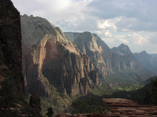
We
went for a short walk out to the Kolob Canyons view point. At dusk,
I walked up the Taylor creek trail a few minutes while Roz laid out
a picnic dinner at the trailhead. We ate dinner as it got completely
dark. We stayed that night in a hotel in Hurricane.
October
1 (Monday)
After making dinner
reservations at the Zion Lodge, we went for our hike in the vicinity.
Since we were staying at the lodge, we were able to park there, and didn't
have to take the shuttle bus into Zion. We started out from the Lodge
parking lot, and first did the Emerald pools. The upper one was the most
interesting, a large pool underneath some cliffs with a huge overhang.
I estimated a million tons of rock were hanging above thin air (OK, mostly
because the cliff extended upwards for hundreds of feet above the overhang,
but it was impressive none the less).
We took the
Kayenta connection trail to the Grotto picnic area, where we had lunch,
and then we started off for the day's 'main event', Angel's Landing.
As we started up, Roz suggested that I walk on ahead and out the West
rim trail a little way, come back, and meet her at the intersection
of the Angel's Landing trail and the W rim trail. As I was heading back
towards Angels Landing, I was getting a feeling of disbelief. No way
could the trail go up that ridge! It was no more than a few feet wide,
rose steeply away from me, and on the side I could see, had vertical
cliffs extending down a thousand feet. At first I assumed that the trail
must extend up the other side, up terrain hidden from me, but a look
through my monocular showed people on the ridge (the other side of the
ridge, although not quite as sheer at the top, was too steep for casual
walking, and did have substantial vertical cliffs somewhat below the
ridge). As I got closer, it became apparent that this climb would easily
be the most terrifying thing I had done since Yosemite's Half Dome.
I met Roz at
the intersection, and we started up. Wherever the ascend crossed an
area of exposure, they had a heavy chain strung between poles set in
the rock. This was not a uniform setup (as with Half Dome), but an off
and on thing, as the route wound its way up the ridge. The longest stretch
of unbroken chain was perhaps a hundred feet long. After ascending several
stretches of chain, to a false summit, Roz announced (to my relief,
actually), that she wasn't going any further. As I climbed the ridge,
I actually saw only a few places where slipping (and letting go of the
chain) would be followed by certain death (after a somewhat lengthy
delay). Unlike half dome, most places on the ascent were not actually
all that terrifying. Nonetheless, Roz and I both heaved a big sigh of
relief as we descended past the last chain. There were only a couple
of spots where I felt the chain could have been installed but wasn't.
It was quite windy, something I could have done without. Thunderclouds
threatening earlier never materialized.
After descending
to the valley floor, Roz and I took the shuttle bus back to the lodge,
took quick showers, and showed up the the restaurant just in time for
our reservations, and after a frustrating and very annoying 45 minute
wait, we were seated. This was one of those high calorie/high fat meals
where just seems inevitable: you know, where after the bread you get
the feeling that you really have eaten enough. To try to work off some
of the excess, I went for a walk afterwards. The moon was full, and
I walked up the road 2-3 miles, up to a triangular pullout they call
the 'big bend'. This was something I had been looking down on all day,
both from the W rim train and Angels Landing, and for some reason, I
just wanted to get there before leaving Zion. After the last bus passed
me just after 10, I saw no other vehicles (an advantage of the mandatory
shuttle system). I did see a couple on the road, and a flash of light
that might have been someone taking a picture at the observatory point
(2000 feet above the valley floor). I saw no one else, and got back
to our cabin about 11:30.
October
2 (Tuesday)
With 'The Lord
of the Rings' in hiatus, we drove through the spectacular Southern Utah
landscape to Bryce National Park. At Bryce, our initial plan was for me
to go backpacking, but the permit lady convinced me to stick with day
hikes in the spectacular Bryce Amphitheater. Starting from Sunset Point,
we headed down the Navaho loop trail. At the bottom, we separated, staying
in touch with our walkie talkies. Roz completed the Navaho loop, while
I did the complete Peekaboo loop trail, and headed up the Queen's Garden
trail, meeting Roz at Sunrise point. We then checked into Ruby's inn,
just outside the park.
October
3 (Wednesday)
The initial plan
for the day was I was going to do the Fairyland loop while Roz rested,
then Roz would drop me off for an overnight backpack that evening. I started
down the Fairyland trail from Fairyland point, completing over half of
the loop without event, taking the side trip to the multiple arches of
'Tower bridge', and observing the structure I am pretty sure they call
the 'Chinese wall'. Shortly after the Chinese wall, however, I took a
bad fall. I walked just a few feet off the trail to look over a low ridge,
and on the way back to the trail, heading diagonally down the slope, my
foot slid out from under me, and I wound up literally kissing the dirt.
My nose took an impact, but was OK. Worse, I had also landed on my left
ribs, and they ached considerably all day. I can't say that I was in agony,
but it hurt whenever I moved. I carefully completed the loop, and was
quite relieved to finally get back to the car. Back at the hotel room,
I informed Roz that I was through for the day. I basically lay in bed
all afternoon, while Roz took the car and did essentially every overlook
in the park. At dinner I took 2 Tylenol and 3 ibuprofen.
When I fell,
I had been using the same hiking boots I had been using for years, since
every new pair I bought gave me problems (ref. Grand Canyon trip Nov.
'00). These boots had been terrific, but I have been unable to find
another pair anywhere. This is what drives me nuts about fashion: find
something you really like, enjoy it while you can, because you will
never, ever, be able to buy it again. As a consequence, the tread on
these boots had been completely worn off. Comfortable as these shoes
were, I have regretfully concluded that they are due for retirement.
The REI boots that had given me so much trouble a year before in the
Grand Canyon were along just in case, and I wore those for the rest
of the trip, pretty much without incident. The new tread on these shoes
gave a refreshing degree of traction. The problem with these boots persist,
however, so they are not suitable for a really long hike, or extensive
hiking over a number of days (these boots were fine on the GCNP trip
until the 11 hour hike). No, they haven't 'broken in': I am convinced
the whole 'breaking in' concept was invented by shoe retailers to persuade
reluctant customers to purchase shoes that don't feel quite right. Every
pair of boots I have ever owned has either never given be problems or
never stopped giving me problems.
October
4 (Thursday)
This morning, I
was much improved. I felt better than I thought I had any right to feel,
much better than I expected. After the pain of all day yesterday, showing
no improvement all day long, this day I felt almost no pain whatsoever.
It was very close to a miraculous recovery. We got up well before dawn
to watch sunrise from Inspiration Point, along with a horde of camera
buffs. We got there only a little after first light, and waited patiently
in the pre dawn chill for sunrise. When the sun came up, it was interesting
to see the colors in the low sun, and we also saw some of the structures
showing a weird glow, backlit from reflected sunlight. After sunrise,
we went over to Bryce point, where a couple years before, Robert and I
had walked down a short distance in an inch of snow. I walked down the
trail just far enough to see how it got down through the rockband. On
the way out of Bryce point, we stopped momentarily at Paria point. Anywhere
else, this would be a very interesting pullout, with cliffs and rock formations,
but compared to the splendor of the Bryce amphitheater, it is not even
an also ran. We were the only people there. Then we went to Fairyland
point, and walked down the trail just a little ways to a social trail
heading out a ridge (this I had also down the day before). We went back
to the hotel, packed, and left. On the way out of the park we took the
short trail to the 'Mossy cave' and a small waterfall.
Outside
of Escalante, we stopped at the BLM/USFS visitor center, and asked about
sites in Escalante. We were told that the only maintained trail in the
monument was to 'Calf Creek Falls'. The 'hole in the rock' road, under
consideration since the last time through the area, when I had purchased
the 'Trails Illustrated' 'Canyons of the Escalante' map, was said to
be an all day venture, if taken all the way to Lake Powell, even without
any side trips. Note the aforementioned map actually covers only about
half the monument. We found a hotel in Escalante, had lunch, and drove
to the 'Calf creek falls' TH. It was mid afternoon by the time we started
out, and I wasn't confident that Roz could make it there and back before
dark, and I recommended that she consider going only part way, but she
informed me that she was going to do the whole thing. The highway parallels
the trail, and in a few places we could see it above us, climbing out
of the valley. It was 3 miles, or maybe just a little less, in to the
falls, which really were impressive, over a hundred feet tall, a good
sized creek coming over the cliffs at the end of the box canyon, with
a pool of emerald water. Roz indeed made it to the falls, and took some
pictures. About half way back, I rushed on ahead, to start cooking dinner
at the picnic tables at the TH. Roz, taking her time, made it back shortly
before I was finished, right about sunset (we stayed in touch with our
radios). We ate dinner by twilight and drove back to our hotel.
October
5 (Friday)
We started out
the hole in the rock road. Roz was not completely behind this venture,
and insisted that I do all the driving. She puts up with my passion for
wilderness, however, even if she doesn't feel it to my extent. I had somewhat
arbitrarily chosen the 'Egypt' trailhead off this road (since it was the
second trailhead: For no particular reason, I didn't want to do the first
trailhead, and we both agreed we didn't want to drive in all the way).
We stopped at the 'Devil's Garden Outstanding Natural Area', and walked
among the rock formations. It was interesting enough, but nothing, really,
compared to Canyonlands NP Needles district, or even Colorado Springs
'Garden of the Gods'. The hole in the rock road, as far as we went, was
wide, well graded, solid surface, but severely washboarded in a lot of
places. You can either drive 40-50 mph, keeping the washboard frequency
well above the natural resonance of your car's suspension (and try not
to think about what this does to all the linkages in the suspension, to
say nothing of further degrading the washboard), or drive 5-10 mph, with
the washboard frequency hopefully below the suspension resonance (if that's
actually possible). Me being what I am, I of course went with the former.
This works until you hit a patch of longer period washboard, where you
struggle to maintain control while slowing down. The access road to the
Egypt trailhead was not as well maintained, with some places near the
end where a low clearance vehicle might have bottomed out. In spite of
seeing only a couple of vehicles on the road, we were surprised to see
the parking lot packed, with about a dozen vehicles there.
From the trailhead,
we could see the Gorge of the Escalante river, several miles distant.
This was evidently where the trail went, although we hadn't seen any
map indicating this for sure. Roz didn't feel like doing this hike,
so I started out by myself, again staying in touch with our radios.
The trail started out down a hill of solid rock. There was a route which
avoided all the dangerously steep places. With her vantage point at
the top, Roz helped guide me down. There were also cairns here and there.
At the bottom, I followed a somewhat casually marked trail, with occasional
cairns and foot tracks, across the flats. I had the presence of mind
to keep looking back, so that on the way back, I would be able to find
the place in the cliffs where I had come down, if I for whatever reason
failed to find the same trail. Before long, heading for the inner ravine,
I was following a dry wash tributary of the Escalante, bounded with
dangerous cliffs in most places (Fence Canyon). The trail was difficult
to follow, but clearly kept me on the North side of the ravine. At one
point I was sure I was supposed to head into the ravine, but after careful
examination, it became clear that the trail stayed on the rim, as I
got closer and closer to the main gorge of the Escalante. Finally, I
came to a point, where an unnamed canyon from the North intersected
Fence Canyon, and the trail headed down into the ravine. Not long after,
I was at the river. I looked around briefly for the trail heading up
and down the Escalante, but the way downstream was blocked by a sheer
rock plunging into the creek. There might have been a trail heading
upstream, but I didn't see one. Evidently people that do these trips
do a lot of wading. The trail appeared to drop down the steep bank into
the creek, which was just clear enough that I could see the bottom,
maybe a foot deep, with a slow but clearly discernible current. I did
see a woman on a sand bank on the other side of the downstream rock.
As I climbed back out, I observed that the downstream rock became the
cliffs on the South side of Fence Canyon, so clearly, the only safe
way to get downstream involves getting your feet wet.
Climbing out
of the ravine (with the usual trail finding problems: I apparently got
waylaid by a trail that went to a small pond) I sure enough found myself
following a different trail across the flat than the one I had descended
on, this time further to the North. Roz called me on the radio, and
reported that, through her binoculars, a person she thought might be
me was me was very close to a large party with lamas. I didn't think
she could possibly have spotted me, since there was no one in sight.
The trail seemed to be veering off to the North, away from where I knew
the route up the cliff was, so a broke off it, following a single track
of footprints in the sand. It turned out Roz had indeed spotted me,
and I caught up to the lama party just before I reached the base of
the cliff. Some of the members of the party seemed to think that because
of Roz's guidance, I had some kind of an edge going up the cliff. They
soon learned otherwise. It wasn't Roz's fault, but I started up the
wrong way, misguided by a sequence of cairns set up in totally the wrong
place. The lama party guide, at least, knew what she was doing, so I
backtracked, and followed them up. With a little assistance from her,
I found the right route, which was for the most part very clear once
I was pointed in the right direction, and I came out just ahead of them,
much to my relief, since I didn't want to follow a lama trailer on the
way out (don't for a minute think that it was due to my competitive
nature). That night I treated Roz to a restaurant dinner in Escalante.
I also waited patiently while she bought some stuff at an antique store.
October
6 (Saturday)
As we started out
from Escalante, we stopped briefly at a pullout a mile up the road from
the (lower) Calf Creek Falls TH. We could see a large portion of the lower
trail, and we could see where the falls clearly were, but the canyon at
that point was narrow and bound by cliffs, and we weren't close enough
to see down into it. We also noted the turn off for the upper falls trail
(not as well maintained), an unmarked dirt road heading off to the West
in between mile markers 81 and 82. The upper falls are said to be almost
as big as the lower. Heading home through Utah, we stopped in Capitol
Reef NP, and did the 3.5 mile chimney rock loop trail, an interesting
diversion in the multicolored Utah geography, yet more cliffs and rock
formations. I did some parts of the trail twice. We also stopped at the
Visitor center and to see some petroglyphs. We never drove more than a
hundred yards off the main highway. We had a picnic lunch in Hanksville,
and then resumed listening to 'The Lord of the Rings', as the Utah landscape
got flatter and less interesting at that point. We had dinner in Glenwood
Springs. We finally got through to Robert, and invited him to join us,
but it was too short notice, and he was not up for it, having spent all
day 4 wheeling in his new Ford Explorer. Just like mine, his didn't go
in and out of 4WD low without some difficulty. We stopped in Dillon for
coffee, and to change drivers: I had been driving ever since we got on
I70. We finished the thirteenth and final tape of the 'Rings' as we ascended
Floyd Hill (talk about timing!), and got home about 10.
|